Hemkund Sahib Yatra
About Hemkunt Sahib
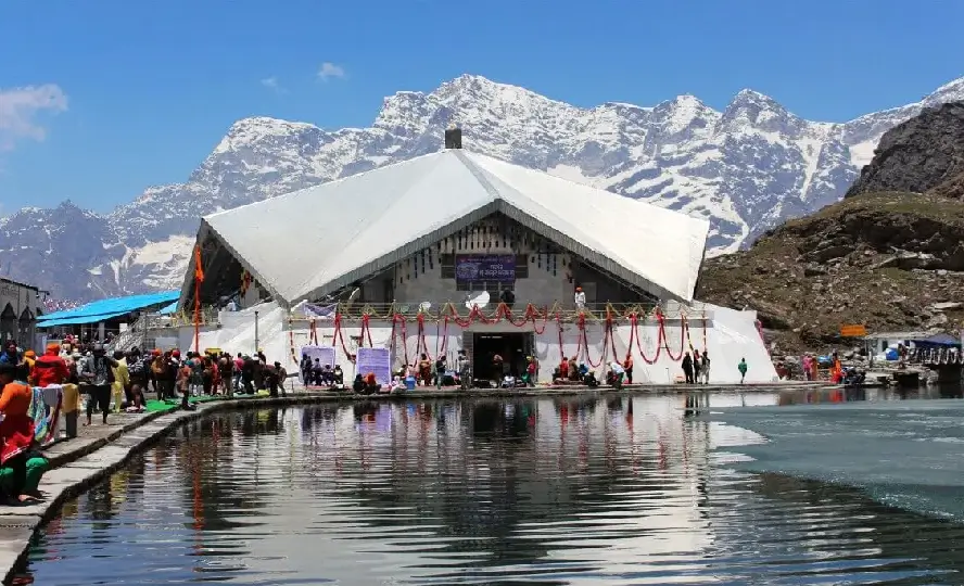
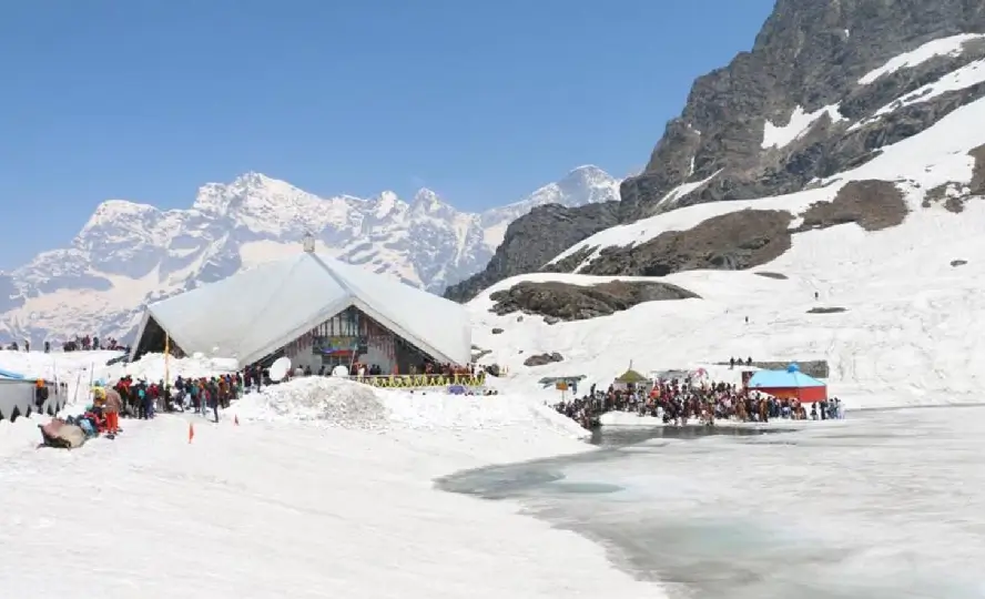
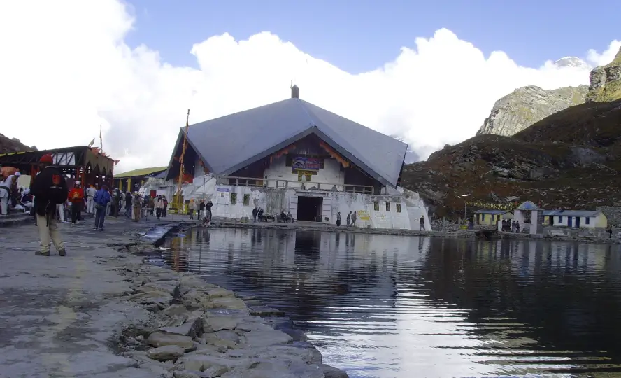
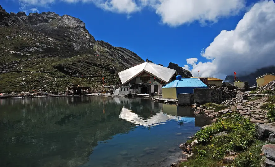
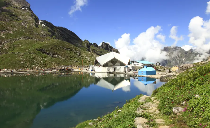
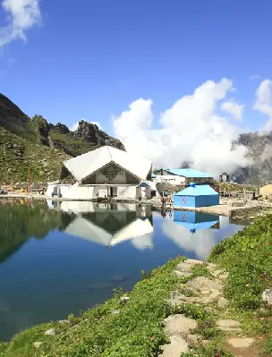
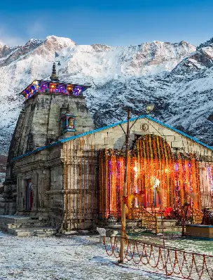
The Hemkund Sahib is the heavenly abode of Guru Gobind Singh Ji, the 10th guru of Sikhs. The gurdwara which is situated at an altitude of 4,329 metres is also known as Gurudwara Sri Hemkunt Sahib Ji. Hemkund Sahib is one of the most popular Sikh pilgrimage sites located in the Chamoli district of Uttarakhand along the banks of Hemkund Lake and surrounded by the Himalayas. The lake is known as Lokpal Lake by local people there. It is necessary to enter the Gurdwara first before taking a holy dip in the lake. The lake is a height of 15,000 feet and a small stream originates from the lake. The mountain peaks here are marked with Nishan Sahib, a Sikh triangular flag.
The holy destination of Sikhs draws thousands of pilgrims every year from all over the world. Hemkund Sahib Yatra is the most difficult pilgrimage tour in Uttarakhand. People approach the Gurudwara from Govindghat which is on the Rishikesh-Badrinath highway. Govindghat is a town located very close to Joshimath. Despite the difficult route, the pilgrims reach this holy place with full devotion.
Important Information About Shri Hemkunt Sahib
| Religious Centre | Hemkund Sahib (Sikh Pilgrimage Site) |
| Coordinates | 30°42'0.78"N 79°36'57.54"E |
| Geographical area | 4,572 m (15,000 ft) |
| Languages Spoken | English, Hindi, Garhwali |
| Places to Visit Near Hemkund Sahib | Hemkund Lake, Valley of Flowers, Ghangaria, Mana Village, Badrinath Dham, Sheshnetra, Tapt Kund, Nanda Devi National Park |
History of Shri Hemkund Sahib
According to the holy book of Sikhs, Guru Granth Sahib, it is mentioned that Guru Govind Singh used to meditate along the sacred Hemkund Lake in one of his earlier lives for 10 years. The mention of this place was already there in the autobiography of Guru Govind Singh, Bichitra Natak, yet the place stayed unexplored for more than two centuries.
The search for this holy shrine Shri Hemkunt Sahib Gurudwara began in the 19th century and the history of this place dates back to 1884 when it was finally traced by Pandit Tara Singh Narotam. The biggest credit goes to renowned Sikh scholar, Bhai Vir Singh for spreading the popularity and significance of this sacred shrine.
Opening and Closing Dates of Shri Hemkunt Sahib
Hemkund Sahib, a shrine of Sikh pilgrims in the Chamoli district of Uttarakhand has announced its portals opening and closing dates. The Hemkund Sahib Trek commences in May and continues till October every year. Read the table below:
| Opening Date | 25 May 2026 (Tentative) |
| Closing Date | 11 October 2026 (Tentative) |
Religious Important of Shri Hemkund Sahib Yatra
Hemkund Sahib Yatra in the Himalayas holds a huge significance among Sikhs as it is an important pilgrimage destination for them. The followers of Sikhism believe that their tenth guru, Guru Govind Singh Ji used to meditate here along the banks of serene Hemkund Lake in his previous life. The Dasam Granth of Sikhs speak briefly that King Pandu used to meditate and practice Yoga here.
The name Hemkund is derived from Sanskrit in which Hem means snow and Kund means bowl. There's also a high respect held in the hearts of Hindus because the holy shine is mentioned in both the books of Ramayana and Mahabharata. According to stories and legends, it is said that Lord Lakshmana, brother of Lord Rama, meditated at this site along with Rishi Medhasa. Tourists and pilgrims visit the nearby temple of Lord Lakshmana during their Hemkund Sahib Tour. Another story says that Lord Lakshman was brought to the banks of Lokpal Lake after getting injured in the battle with Meghnath. Hanuman gave him the Sanjivani Booti for his cure and the Gods showered flowers from the sky, which later became the famous tourist spot 'Valley of Flower's.
How to Reach Hemkund Sahib?
The question always arises in the minds of devotees, how to reach this holy shrine without any hassle, below are the best ways to reach the popular Sikh shrine in the Himalayas.
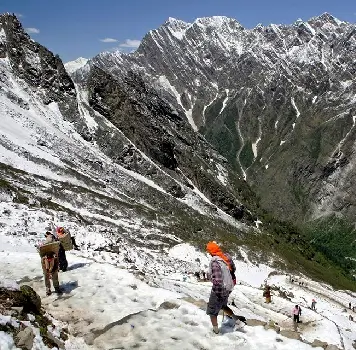
- By Airways: The nearest airport to reach this region is Jolly Grant Airport. After landing one needs to hire a cab or take a bus to reach the base point and after that one needs to follow the Hemkund Sahib trekking route to reach the sacred shrine. Helicopter services are also provided to the people who find the 19 kilometre trekking route too difficult, the service is available from Govindghat to Govind Dham, also known as Ghangaria. This is the last 6 kilometres area to reach the Hemkund Sahib Gurudwara. The helicopter ride will take 8-10 minutes and this makes visiting Hemkund Sahib hassle free. However, the climate conditions are unpredictable in the region, so plan accordingly.
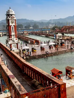
- By Railways: Rishikesh Railway Station will be the nearest railway station which is almost 270 kilometres from Govindghat on NH 58. People can also get down at Haridwar Railway Station which is almost 283 kilometres. To reach the sacred destination, private buses and taxis from Haridwar and Rishikesh are available. After reaching the nearest bus station, one has to take a 19 kilometre trek to reach the abode of Guru Granth Sahib.
- By Roadways: The motorable roads end at Govindghat, after that, there's a 19 kilometre long stretch of trekking route to reach Hemkund Sahib. Govindghat is connected to NH 58. People either opt for trekking the whole path or sit on a pony to reach the temple. From different cities, private buses are available to reach Hemkund Sahib. The buses ply from Haridwar, Rishikesh, Rudraprayag, Srinagar, Chamoli and several other places in Uttarakhand.
Places to Explore Nearby Hemkund Sahib
While doing the Hemkund Sahib Yatra in Uttarakhand, people can travel to several other destinations. There are various places to explore nearby Hemkund Sahib Gurudwara, ranging from lakes, temples and many other tourist attractions.
Hemkund Lake
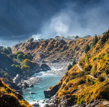
The mesmerising lake located just beside the Hemkund Sahib Gurudwara is called Hemkund Lake. The locals of the Uttarakhand region call this the Lake Lokpal. The lake is given the title of 'Lake of Snow' and is surrounded by magnificent mountains ranging about 15,000 feet in the Chamoli district of Uttarakhand. The glaciers of Saptarishi Peak and Hathi Parvat nourish the lake. A small stream Himaganga emerges from the lake. It is advised to the pilgrims to enter the temple first before taking a holy dip in the sacred lake.
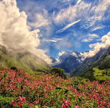
Valley of Flowers
Valley of Flowers which is spread over an area of 87 square kilometres provides an unforgettable experience for the visitors. The Valley of Flowers is at an altitude of 3,600 metres above sea level and is now listed among the UNESCO World Heritage Sites and forms one of the core zones of Nanda Devi Biosphere Reserve. As the name suggests, Valley of Flowers is a breathtaking location which consists of 600 species of flowers like Orchids, Poppies, marigolds, Daisies, Anemones and several others. The area is surrounded by forest birch and rhododendrons; one can also get views of stunning waterfalls and rushing streams on their way to the valley. The valley is also home to wildlife species like Grey Langur, Flying squirrels, the Himalayan weasel, Black bear, Red fox, Lime Butterfly, Snow Leopard and many others.
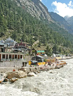
Ghangaria
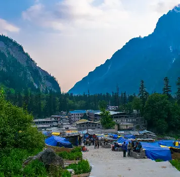
Ghangaria is the popular base camp of Chamoli district, where the two huge Pushpawati and Hemganaga meet and then flow as Lakshman Ganga. Ghangaria is the final human settlement before reaching the Valley of Flowers. Ghangaria is located at an altitude of 3,050 metres close to the popular Gurudwara, Hemkund Sahib and also features a helipad. The location can be reached after a 13 kilometre trek from Govindghat while enjoying the mesmerising views of the Himalayas. The valley gets covered in snow in the winter.
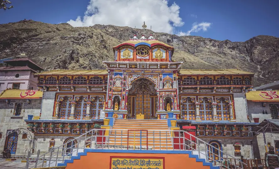
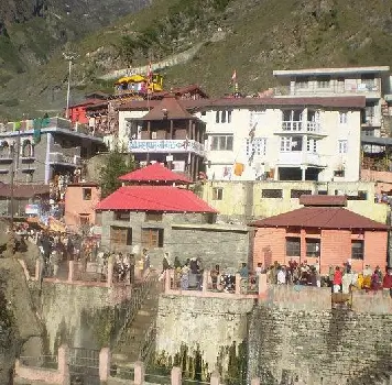
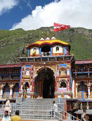
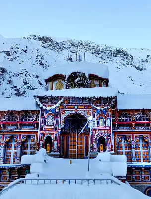
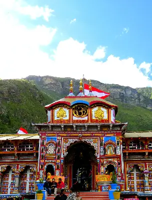
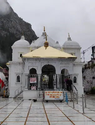
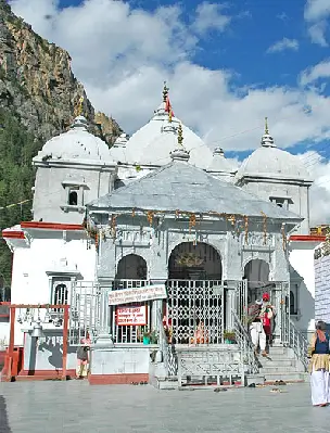
Badrinath Temple
Badrinath Dham is one of the Char Dhams that also includes Yamunotri, Gangotri and Kedarnath. Badrinath Temple also known as Badrinarayan Temple draws a large number of pilgrims every year, thus becoming one of the most important Hindu pilgrimage spots in Northern India. The temple is located at an elevation of 3,100 metres above sea level in the Garhwal Himalayas along the banks of the Alaknanda River. The sacred town lies between Nar and Narayan mountain ranges which is believed to have been established by Guru Adi Shankaracharya in the 8th century. Badrinath Temple stays open for six months and remains closed for the rest of the months due to heavy snowfall.
Mana
Mana Village became highly popular in the last few years as India's first village which lies along the Saraswati River. The Mana Village is located on the northern terminus of NH 7. The village lies on the Indo-China border and is surrounded by snow-capped mountains. Mana Village is home to Indo-Mongolian tribes called Bhotias. The tribe gets majorly involved in the cultural activities of the Badrinath Temple which includes the annual fair Matha Murthi. Badrinath Temple is only 3 kilometres away. During winter, the population of the village comes to a lower altitude as the whole area is covered in snow.
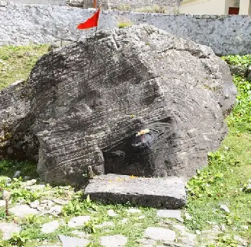
Sheshnetra
A few miles away from the Badrinath Temple lies a huge stone called Sheshnetra which has become one of the most visited tourist attractions in Uttarakhand. The rock resides on the lap of Nar Parvat and is on the opposite side of the fast flowing Alaknanda River, between two tiny seasonal lakes. The boulder is named after the famous mythological snake, Sheshnag. Many people believe that an eye can be seen formed on the rock that gives an unnatural resemblance to the Sheshnag. During the Badrinath trek, the boulder falls between the route as a tourist attraction. The site also makes a great picnic spot to relax and enjoy the views of the surroundings.
Tapt Kund
Tapt Kund is believed to be the abode of Lord Agni or the fire god and is situated very close to the Badrinath Dham and a few kilometres away from Hemkund Sahib. The Kund is a natural hot water spring that remains at 45 degree temperature and people from far off places come to take a holy dip in the Tapt Kund before entering the temple. The water at Tapt Kund comes from Garur Shila and devotees believe that by taking a dip in this holy water, they will get relieved of their sins.
Nanda Devi National Park
To enjoy the wilderness in the upper region of the Himalayas, Nanda Devi Biosphere Reserve which is listed among the UNESCO World Heritage Site is a complete blend of flora and fauna. The Nanda Devi Biosphere Reserve is also known as the Nanda Devi National Park and lies between the Zanskar mountain range and the Great Himalayas. The national park is spread across three districts of Uttarakhand which include Chamoli, Pithoragarh and Bageshwar covering an area of over 6,407 sq km. The biosphere reserve is divided into two zones named Nanda Devi National Park and Valley of Flower National Park. The diversity of flora and fauna in the national park includes endangered, rare and magnificent species such as the Snow leopard, the Himalayan musk deer, the Asiatic black bear, and many other species. It is also a great location for birdwatching.
Frequently Asked Questions
The trekking distance from Govindghat to Hemkund Sahib Gurudwara is approximately 19 kilometres.
No, one cannot stay at Hemkund Sahib at night, it is advised to leave by 2 pm to reach the base camp, Govindghat by dusk.
Yes, private Helicopter charter services are provided, the service is available from Govindghat to Govind Dham, also known as Ghangaria. It is best to check the availability prior.
Popular Tours
Book The Tour
Char Dham Temples
Hotels in Chardham Circuit
Char Dham Tour Packages
- Char Dham Yatra From Delhi
- Chardham Yatra From Mumbai
- Char Dham Yatra From Ahmedabad
- Chardham Tour with Hemkund Sahib
- Chardham Yatra by Helicopter
- Char Dham Yatra with Vaishno Devi & Amritsar
- Chardham Tour with Gomukh Trek
- Char Dham Packages From Bangalore
- Chardham Yatra From Chandigarh
- Char Dham Yatra with Auli
- Char Dham Yatra From Hyderabad
- Char Dham Yatra with Vaishno Devi, Jwalaji & Amritsar
- Char Dham Yatra From Chennai
- Chardham Packages From Bhopal
- Char Dham Yatra by Luxury Vehicle
- Char Dham Yatra with Satopanth Lake
- Char Dham Yatra with Panch Badri Tour
- Char Dham with Valley of Flowers
- Chardham Yatra with Mahavatar Baba and Nainital Tour
Do Dham Yatra
- Badrinath Kedarnath Yatra From Haridwar
- Badrinath Kedarnath Yatra
- Gangotri Yamunotri Yatra
- Gangotri Yamunotri Yatra from Haridwar
- Kedarnath Badrinath Yatra with Hemkund Sahib
- Kedarnath Badrinath Yatra with Valley of Flowers
- Kedarnath, Badrinathdham With Lake Of Nainital
- Yamunotri, Gangotri with Lake of Nainital
Ek Dham Yatra
- Badrinath Pilgrimage Tour
- Kedarnath Pilgrimage Tour
- Gangotri Pilgrimage Tour
- Yamunotri Pilgrimage Tour
- Kedarnath Yatra By Helicopter
- Badrinath Dham Yatra from Haridwar
- Badrinath Yatra with Hemkund Sahib
- Badrinath Yatra with Valley of Flowers
- Gangotri Dham Yatra with Gaumukh
- Kedarnath Dham Vasuki Tal Trek